Make your own discovery of the natural wonders of Antarctica and the Antarctic. Your guide is our current and historical maps, posters, satellite images, and aerial photography. Use and enjoy these in the field, office, classroom, and home.
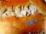
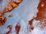
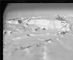
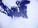
McMurdo Dry Valleys, Antarctica
Map TAN0158
Satellite image map of the
McMurdo Dry Valleys
region from 77° to 78°
South latitude and from
159° 20' East to 163° 57'
East longitude.
|
USGS Store
Use this 1:1,000,000-scale
map to examine the status of
this fantastic ice-free zone of
Antarctica with its mysterious
Lake Vanda.
|
|
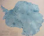
Satellite Image Map of Antarctica,1996
Map I-2560
Ferrigno, Jane G and others.
Use this map of the entire Antarctica continent from a mosaic of satellite images to teach and learn about the physical geography of the continent. |
USGS Store
This map contains fewer labels than Map I-2284 and therefore it is useful to examine the surface of Antarctica.
|
 |
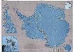
Antarctica Satellite Image Map
Map I-2284
Map created from imagery from the Advanced Very High Resolution Radiometer.
|
USGS Store
USGS Education Map Catalog
Use this map of the entire Antarctica continent from a mosaic of satellite images to teach and learn about the physical geography of the continent.
|
|
Hut Point Peninsula Satellite Image Map
Map made from Landsat
and SPOT satellite
images of the Earth's
surface at Hut Point
between 1986 and 1995,
using visible and infrared
bands.
|
USGS Store
Use this satellite image map to
investigate the landscape of
Hut Point Peninsula, near 77°
50' South and 166° 45' East, at
1:25,000 scale.
|
|
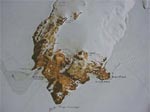
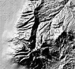
Mt. Discovery, Antarctica Satellite Image Map, Landsat 1988
Map made from Landsat
satellite images of the
Earth's surface at Mt
Discovery, dated 1988.
|
USGS Store
Use this map to investigate the
landscape of Mt Discovery
Sound at a scale of 1:250,000.
|
|
Plunket Point, Antarctica Satellite Image Map, Landsat 1988
Map made from Landsat
satellite images of the
Earth's surface at Plunket
Point, dated 1988.
|
USGS Store
Use this map to investigate the
landscape of Plunket Point at a
scale of 1:250,000.
|

|
Radarsat Image Map of Antarctica
The first high-resolution
radar map of Antarctica,
made from a mosaic of
over 400 Radarsat
Synthetic Aperture Radar
images, with insets of the
Antarctic Peninsula and
the South Ross Sea, at a
scale of 1:5,000,000.
|
USGS Store
Map Number 115261
Use this map to investigate
Antarctica at a continental and
yet a detailed scale, as the
mosaic was made from 25-
meter resolution imagery.
|
|
Marble Point, Antarctica Satellite Image Map, 1986-1995
Map made from Landsat
and SPOT satellite
images of the Earth's
surface at Marble Point
between 1986 and 1995,
using visible and infrared
bands.
|
USGS Store
Use this satellite image map to
investigate the landscape of
Marble Point near 77° 35'
South and 164° East, at
1:25,000 scale.
|
|
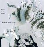
Ross Island and McMurdo Sound Satellite Image Map
Map made from Landsat
satellite images of the
Earth's surface at Ross
Island and McMurdo
Sound, dated 2000.
|
USGS Store
Product number 39315.
Use this map to investigate the
landscape, ocean, and ice at
Ross Island and McMurdo
Sound at a scale of 1:100,000.
|

|
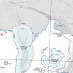
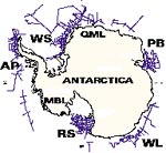
Coastal-Change and Glaciological Maps of Antarctica
Results of analyses in 23
maps as I---2600--A--W of the
USGS Geologic
Investigations Series (I--
Maps) (fig. 2). Most
1:1,000,000-scale maps
extend to the southernmost
nunatak within each map
area or to the southernmost
extent of Landsat images
(about 81.5°S. lat.), although
for some ice shelves,
RADARSAT or MODIS
images were used to extend
maps further south.
|
https://pubs.er.usgs.gov/publication/fs20053055
Contains index map showing the
locations and names of the 23
published and planned
1:1,000,000-scale coastal-change
and glaciologic maps of
Antarctica. The dates (2004) of
published maps are shown that
are available in print and digital
formats.
|

|
Coastal-Change and Glaciological Map of the Eights Coast Area,Antarctica: 1972-2001 2004
By Charles Swithinbank et al.
Map I-2600-E
Changes in the area and
volume of polar ice sheets
are linked to changes in
global climate, and the
resulting changes in sea
level may severely impact
the densely populated
coastal regions on Earth.
Melting of the West
Antarctic part alone of the
Antarctic ice sheet could
cause a sea-level rise of
approximately 6 meters
(m). In spite of its
importance, the mass
balance of the Antarctic
ice sheet is poorly known,
and hence was the reason
to create these maps.
|
http://pubs.usgs.gov/imap/2600/E/
USGS Store
Use this 1:1,000,000-scale
map to examine the status
and changes in the Eights
Coast area of Antarctica via
satellite imagery.
|
|
Aerial Photography of Antarctica
The USARC holds
approximately 400,000
aerial photographic prints
from 1947 to the present.
The photography was
flown in support of NSF
funded mapping and
research by the USGS.
These prints are spatially
indexed and viewable in
the USARC or are
available online through a
link from the USARC web
page.
In addition to the vertical
photographs many of the
early aerial photography
included views to both the
left and right using three
cameras "trimetrogon" that
took pictures
simultaneously.
|
1) Online: https://libraryguides.usgs.gov/antarcticresearch
2) By visiting the USARC in Reston, VA.
3) Although flight indexes,
coordinates and map names
can be viewed and
downloaded from the internet
(URL above) photographic
prints must be ordered
through the Center for Earth Resources Observation and Science (EROS).
|
|
Scientific Committee on Antarctic Research Aerial Photography
The Scientific Committee
on Antarctic Research
(SCAR) provides aerial
photography and maps of
Antarctica for scientists
and others to determine
geologic features, analyze
ice stream flow, and
monitor penguin and seal
populations. Various
mapping cameras and film
types have been used to
create over 300,000
frames of film since 1946,
with annual acquisitions
since 1980.
The majority of film is
panchromatic black and
white, and more recent
acquisitions include
natural color and color infrared
films, being
archived mainly on 9-inch
film. Less than 10 percent
of the photography
(30,000 frames) is on 70-
mm film. Spatial
resolutions vary as a
function of photographic
scale. Photographic
scales range from 1:1,000
- 1:64,000.
|
https://lta.cr.usgs.gov/aerial_antarctic
Examine Antarctica using
aerial photography.
The original negative film is
stored at the USGS EROS
Data Center. The USGS
archives all film taken over
Antarctica and held in the
U.S. except for some
photographs acquired during
1946 - 1948, which are stored
in Washington, DC at the
National Archives.
The USGS maintains a SCAR
library which is a repository
and distribution site for all
cartographic materials
covering Antarctica that are
produced by the United
States and other participating
SCAR nations. The SCAR
library is located at the USGS
National Center in Reston,
VA.
|
|
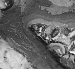
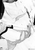
Amundsen-Scott South Pole Station Aerial Photo Map
Large aerial photograph
taken from 762 meters
(2500 feet) in altitude
showing the buildings and
landscape at the South
Pole. Date: 1983
|
USGS Store
What does the land look like at
the South Pole? Use this
map/aerial photograph to find
out. This map is quite detailed
(1:1250), allowing close
investigations of people and
activity.
|
|
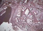
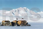
McMurdo Station, Antarctica Aerial Photo Map
Map made from aerial
photograph taken at 3000
feet in altitude on 2
February 1999.
|
USGS Store
Product number 39326.
Use this aerial photo map and
accompanying ground photo to
investigate the landscape of
McMurdo Station and human
activity at a detailed scale of
1:1560.
|
|
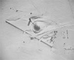
Hut Point, Antarctic Aerial Photo Map, 1983
Large aerial photograph
taken from 7925 meters
(26,000 feet) in altitude
showing the buildings and
landscape at the South
Pole. Date: 1983
|
USGS Store
Use this map/aerial photograph
to investigate rocks, ice, and
human activity at a detailed
scale (1:13,500).
|
|
Discovering Antarctica
All resources available from this site are subjected to copyright and may be downloaded and used for educational purposes only.
|
Discovering Antarctica
|
|
Royal Geographical Society Enterprises
Our extensive polar collections includes material relating to the British Antarctic expeditions of the early 20th century, and in particular the key achievements and experiences of two eminent figures of Antarctic exploration: Robert Falcon Scott and Ernest Shackleton.
|
Antarctic Collection
|
|
Landsat Satellite Images of Antarctica
|
Access Landsat Scenes
New Landsat Image Mosaic of Antarctica
|
 |
Coastal-Change and Glaciological Maps of Antarctica
Results of analyses in 23
maps as I---2600--A--W of the
USGS Geologic
Investigations Series (I--
Maps) (fig. 2). Most
1:1,000,000-scale maps
extend to the southernmost
nunatak within each map
area or to the southernmost
extent of Landsat images
(about 81.5°S. lat.), although
for some ice shelves,
RADARSAT or MODIS
images were used to extend
maps further south.
|
https://pubs.er.usgs.gov/publication/fs20053055
Contains index map showing the
locations and names of the 23
published and planned
1:1,000,000-scale coastal-change
and glaciological maps of
Antarctica. The dates (2004) of
published maps are shown that
are available in print and digital
formats.
|
|
EROS Elevation Products including Antarctica
|
https://lta.cr.usgs.gov/GTOPO30
|
|
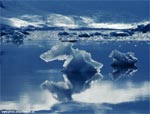
Earthshots Satellite Images of Global Change: Antarctica
These images show the
seaward edge of the
Filchner Ice Shelf, on the
coast of Antarctica, facing
the Atlantic. In the austral
winter of 1986, the front
edge of the Filchner Ice
Shelf broke off into the
sea, forming three large
icebergs. This was a
major, long-awaited
calving.
|
https://earthshots.usgs.gov/earthshots/Filchner-Ice-Shelf#ad-image-0
Use this site to examine
changes that can be detected
via Landsat satellite imagery,
and read the explanatory text
provided.
|
 |
Shuttle Radar Topography Mission Elevation Data (SRTM)
Digital elevation data of
the Earth's surface,
including the polar
regions, at 90-meter
spatial resolution from
which can be derived
shaded relief, slope maps,
contours, direction of
slope, and more.
|
https://earthshots.usgs.gov/earthshots/Filchner-Ice-Shelf#ad-image-0
Use this site to examine
changes that can be detected
via Landsat satellite imagery,
and read the explanatory text
provided.
|
 |
Antarctic Seismic Data Library
The Antarctic Seismic
Data Library System
provides open access
worldwide to Antarctic
multichannel seismic reflection
data collected
by many countries to
study the structure of the
earth's crust of Antarctica.
|
https://scar.org/library-data/data/seismic-data
Investigate seismicity of
Antarctica with this data library.
|
 |
Download Plug-in
Some of the links on this page require a plug-in to view them. Links to the plug-ins are available below.
 Adobe Acrobat Reader (PDF) Adobe Acrobat Reader (PDF)
|